What Is an Earthquake Fault?
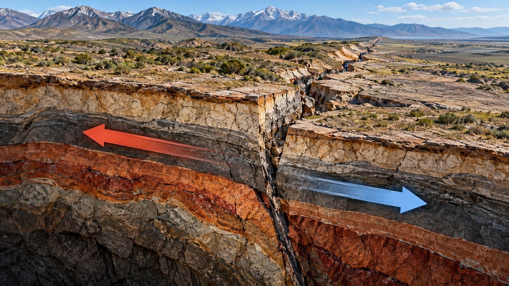
News coverage of earthquakes often mentions a fault by name: the San Andreas, the Hayward, the North Anatolian. But what exactly is a fault, and does living near one mean an earthquake is coming soon?
This article explains what faults are, the main kinds, how scientists decide whether a fault is active, and what happens when a fault breaks the ground surface.
Quick answer
A fault is a fracture, or zone of fractures, in the Earth's crust where the rocks on either side have moved past each other. Earthquakes happen when stress builds up on a fault and it slips suddenly. Faults are described by how they move (strike-slip, normal or reverse), and scientists classify them as active if they have moved in the geologically recent past and could produce future earthquakes.
A fault is a break where rocks have moved
Rocks in the Earth's crust are under constant stress from the slow movement of tectonic plates. When rock breaks and the two sides shift relative to each other, the break is called a Fault. A crack where the rock has not moved is called a joint, not a fault.
The surface along which the rocks slide is the fault plane. Fault planes can be nearly vertical or gently sloping, and they extend from near the surface down to depths of many kilometers. The line where a fault meets the ground surface is called the fault trace. That is the line you see on fault maps.
Faults range in size from a few centimeters long to more than 1,000 kilometers. The San Andreas Fault, for example, runs for more than 650 miles (over 1,000 kilometers) through California, according to the USGS.
The main types of faults
Faults are classified by the direction the rocks move. On sloping faults, geologists call the block above the fault the hanging wall and the block below it the footwall.
| Fault type | Movement | Typical setting |
|---|---|---|
| Strike-slip | Blocks slide horizontally past each other | Transform plate boundaries, such as the San Andreas |
| Normal | Hanging wall moves down relative to footwall | Where the crust is stretching, such as Nevada or rift valleys |
| Reverse | Hanging wall moves up relative to footwall | Where the crust is being squeezed |
| Thrust | A low-angle reverse fault; one block pushed over the other | Mountain belts and subduction zones |
| Oblique-slip | A combination of sideways and up-or-down movement | Common wherever stresses are mixed |
Active and inactive faults
Many faults formed millions of years ago and have not moved since. Others are still slipping and producing earthquakes. Scientists look for signs of recent movement, such as offset young soils, displaced streams, recent earthquakes on the fault or measurable strain from GPS.
Definitions of active vary by purpose. The USGS Quaternary Fault and Fold Database includes faults with evidence of movement in roughly the last 1.6 million years. California's Alquist-Priolo Earthquake Fault Zoning Act focuses on faults that have ruptured the surface in about the last 11,000 years, and it limits building directly on top of those fault traces.
A fault that has been quiet for a long time is not necessarily safe. Some faults have long gaps between large earthquakes, sometimes hundreds or thousands of years.
Faults are often zones, not single lines
On a map a fault may look like a single neat line, but at ground level it is often a zone of many parallel and branching breaks, sometimes hundreds of meters wide. Major plate boundaries are usually made of several faults working together. In the San Francisco Bay Area, for example, plate motion is shared among the San Andreas, Hayward, Calaveras and other faults.
Not every earthquake happens on a known fault. Some faults are buried and do not reach the surface; these are called blind faults. The 1994 Northridge earthquake in Los Angeles happened on a blind thrust fault that had not been clearly identified beforehand.
How scientists find and map faults
Geologists use several tools to locate faults and understand their history.
- Field mapping of landforms such as long straight valleys, steep scarps, sag ponds and offset streams.
- Lidar, a laser mapping method that can reveal fault scarps hidden under trees and vegetation.
- Trenching across a fault to read layers of soil that have been broken and offset by past earthquakes, and dating those layers.
- Locating small earthquakes, which often line up along faults that are not visible at the surface.
- GPS and satellite radar to measure how fast the ground on either side of a fault is moving.
Surface rupture
In large, shallow earthquakes, the slip on the fault can reach the ground surface. This is called surface rupture. It can offset roads, fences, pipelines and buildings that sit directly on the fault, sometimes by several meters in the largest events. In the 1906 San Francisco earthquake, fences and roads along the San Andreas were offset sideways by several meters.
Surface rupture causes damage only along a narrow strip, while shaking affects a much larger area. That is why both fault-zone building rules and strong building codes matter. For most people, shaking is the bigger concern than the fault itself.
What living near a fault means
Being close to a fault raises your chance of experiencing strong shaking, but shaking from a large earthquake can be damaging tens of kilometers away, and soft soils can make it worse. Rather than focusing only on the nearest fault line, check the official hazard information for your area and take steps to prepare. Our guide on how to prepare for an earthquake is a good place to start, and you can see recent activity near you on the live map.
Frequently asked questions
How can I find out if I live near a fault?
In the United States, the USGS Quaternary Fault and Fold Database has an interactive map of known faults. In California, the California Geological Survey publishes fault zone maps. Your local emergency management agency can also point you to hazard maps for your area.
Is the San Andreas the most dangerous fault in California?
It is the longest and best known, and it can produce very large earthquakes. But other faults, such as the Hayward Fault in the Bay Area and faults beneath the Los Angeles basin, run directly under dense populations and also pose serious hazards.
Can a fault be inactive and then become active again?
Yes. Old faults are weak zones in the crust, and if stresses change, they can be reactivated. Some induced earthquakes, for example, happen on old faults that were reactivated by fluid injection.
Do faults creep without earthquakes?
Some do. Parts of certain faults, including a section of the San Andreas in central California and parts of the Hayward Fault, slowly creep, slipping steadily without large earthquakes. Creep can bend curbs and walls over time.
Key takeaway
A fault is a break in the crust where rocks have moved, and earthquakes are sudden slip on faults. Scientists map faults and judge them active based on recent movement, but shaking reaches well beyond the fault line, so preparedness matters across the whole region.
Sources
- Faults — U.S. Geological Survey
- What is an earthquake and what causes them to happen? — U.S. Geological Survey
- Earthquake Hazards Program — U.S. Geological Survey