How Does Earthquake Detection Work?
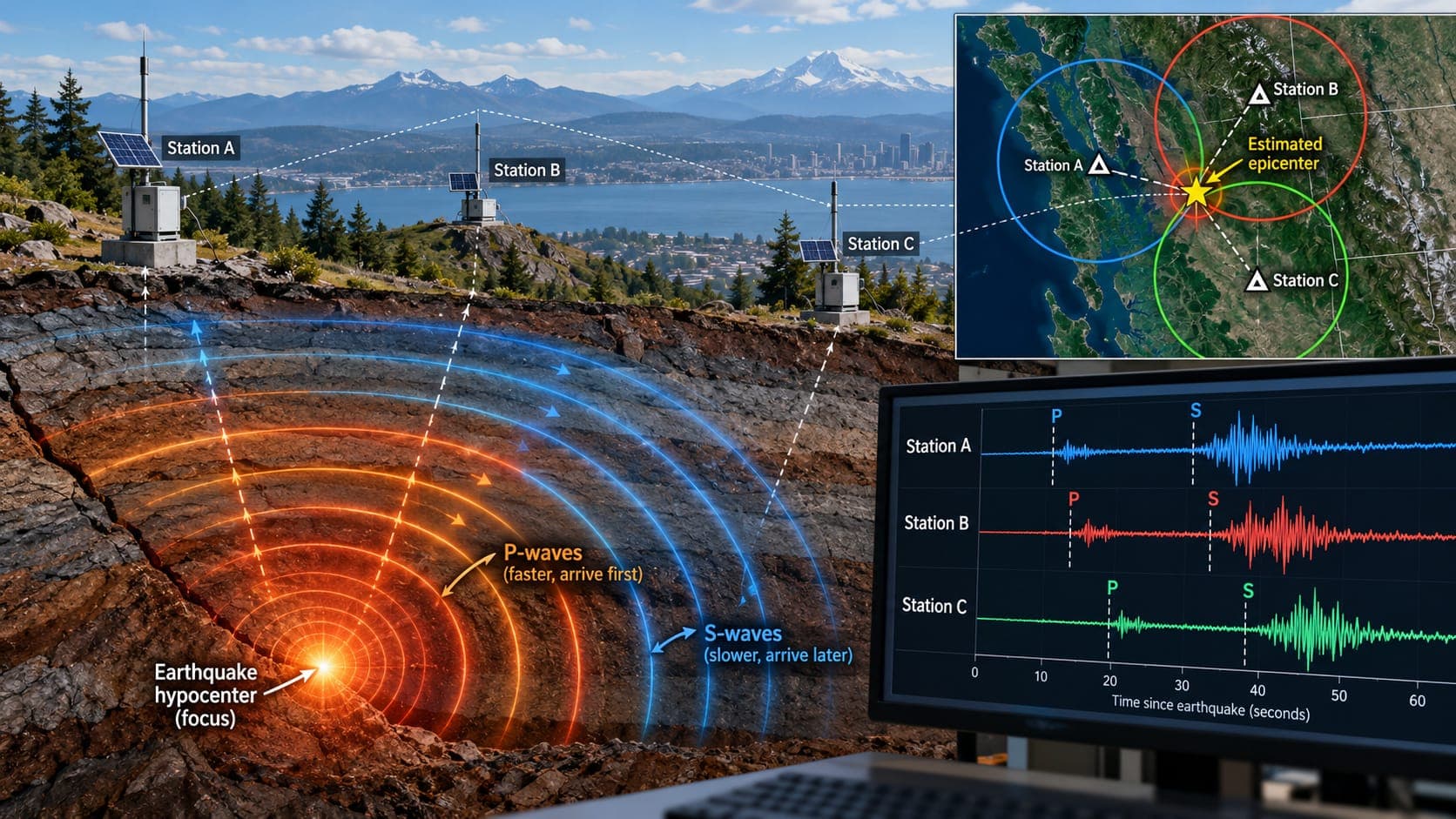
Within minutes of an earthquake, its location and magnitude can appear on maps around the world. That speed comes from thousands of instruments, fast data links and decades of refined methods working together. Understanding the process also explains why the first numbers you see often change.
This article follows an earthquake from the moment the ground starts moving to the reviewed solution that ends up in official catalogs.
Quick answer
Earthquakes are detected by seismometers that record ground motion and send data continuously to processing centers. Computers spot the arrival of seismic waves at several stations, use the differences in arrival times to locate the earthquake, and measure the waves to estimate magnitude. An automatic solution is usually published within minutes, then seismologists review it and may revise the location, depth and magnitude.
Seismometers: the basic sensor
A seismometer measures how the ground moves. Modern instruments convert tiny motions into electrical signals that are digitized many times per second. Some are extremely sensitive and can record distant earthquakes on the other side of the planet. Others, called strong-motion sensors or accelerometers, are designed to stay on scale during violent shaking close to a large earthquake.
Stations are placed in quiet locations when possible, such as boreholes or vaults on solid rock, because traffic, wind and ocean waves create background noise that can hide small earthquakes.
Networks of stations
A single seismometer can show that something happened, but it takes several stations to locate an earthquake. Stations are organized into networks that share data in real time.
In the United States, the Advanced National Seismic System (ANSS) brings together the USGS and regional networks, many run by universities. Globally, the Global Seismographic Network (GSN), operated with partners including EarthScope (formerly IRIS), provides high-quality stations around the world. Many countries run national networks, and agencies share data across borders.
Station density matters. In parts of California, networks can detect very small earthquakes. In remote areas or under the oceans, where stations are sparse, only larger earthquakes are reliably detected and locations are less precise.
Reading the waves: P and S
An earthquake releases several kinds of seismic waves. The P wave is a compression wave and travels fastest, so it arrives first. The S wave is a shearing wave that travels more slowly and arrives later. Surface waves, which travel along the outside of the Earth, follow.
The gap between the P and S arrivals at a station grows with distance. A station that sees them only a second or two apart is close to the source. A station that sees them minutes apart is far away. This simple fact is the foundation of earthquake location.
Locating the earthquake
Software watches each station for a sudden change in the signal and marks it as a wave arrival, called a pick. When several stations report picks that fit together, the system declares a possible earthquake.
It then searches for the point in the Earth, and the start time, that best explains all the arrival times, using models of how fast waves travel through different layers. The result is the Hypocentre (focus) (the point underground where rupture began), its Epicentre on the surface and its Depth. Depth is usually the hardest part to pin down, especially when no station is close to the earthquake.
Estimating magnitude
Once the location is known, Magnitude is estimated from the size of the recorded waves, corrected for distance. Different methods suit different earthquakes. Small, local quakes are often measured with local magnitude scales. For moderate and large earthquakes, seismologists prefer moment magnitude, which reflects the fault area and slip and does not level off for very big events.
Moment magnitude needs longer stretches of data, often from distant stations, so it may appear minutes after a first estimate. That is one reason the magnitude of a large earthquake can be revised upward or downward.
Automatic versus reviewed solutions
The first solution you see is usually automatic: produced by software with no human check. For U.S. earthquakes, automatic solutions often appear within a few minutes, while distant earthquakes can take longer because waves need time to reach enough stations.
Seismologists then review the picks, remove bad data, add more stations and recompute. The event's review status changes from automatic to reviewed. Location, depth and magnitude can shift, and occasionally an automatic event is deleted because it was noise or a duplicate. You can see how these changes play out on EQRadar's event updates page.
| Value | Why it may change |
|---|---|
| Magnitude | Better method or more stations; moment magnitude replaces a quick estimate |
| Location | More arrival times and corrected picks |
| Depth | Hard to constrain without nearby stations |
| Existence | Rarely, a false or duplicate event is deleted |
GPS, phones and other sensors
Seismometers are not the only tools. High-precision GPS and other satellite positioning (GNSS) stations measure how the ground permanently shifts during large earthquakes. They help estimate the size of very large quakes, where seismometers alone may underestimate it, and they track slow fault movement over years.
Smartphones contain accelerometers too. Systems such as Android Earthquake Alerts combine signals from many phones to detect shaking, and apps like MyShake have explored phone-based sensing. Phones are noisier than scientific instruments, but large numbers of them can add coverage. Public reports through the USGS Did You Feel It? program add another layer, showing how strongly people felt the shaking, which feeds into maps of Intensity and ShakeMaps.
Frequently asked questions
How fast is an earthquake detected?
Early warning systems can detect an earthquake within seconds. Published automatic locations and magnitudes usually take a few minutes for local events and longer for distant ones. Reviewed solutions can take from minutes to hours or more.
Why did the magnitude of an earthquake change after it was first reported?
The first number is an automatic estimate made with limited data. As more stations are included and seismologists review the event, a better method, often moment magnitude, may give a different value.
Can every earthquake be detected?
No. Very small earthquakes are detected only where stations are dense. In remote regions and under the oceans, the smallest reliably detected magnitude is higher.
How many stations are needed to locate an earthquake?
In principle at least three or four, but in practice networks use many more to improve accuracy and reject bad data.
Key takeaway
Earthquake detection relies on networks of seismometers that record P and S waves. Arrival times locate the earthquake and wave sizes give its magnitude. Automatic results appear within minutes and are then reviewed, which is why early numbers often change.
Sources
- Earthquake Hazards Program — U.S. Geological Survey
- Latest Earthquakes — U.S. Geological Survey
- Did You Feel It? — U.S. Geological Survey
- EarthScope Consortium — EarthScope