What Is an Earthquake Epicenter?
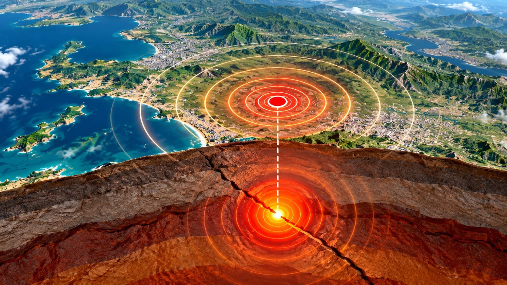
Every earthquake report starts with a location: a dot on a map and a line such as 10 km NE of a town. That dot is the epicenter. It is one of the most useful pieces of information about an earthquake, but it is also easy to misread.
This article explains what the epicenter is, how it relates to the hypocenter, how scientists find it within minutes, and why the place with the strongest shaking is not always right at the epicenter.
Quick answer
The epicenter is the point on the Earth's surface directly above where an earthquake started. The starting point itself, underground, is called the hypocenter or focus. Seismologists locate both by comparing when seismic waves arrive at many different seismometers. For small earthquakes, the epicenter is a good guide to where shaking was strongest, but large earthquakes rupture long stretches of fault, so strong shaking can extend far from the epicenter.
Epicenter vs hypocenter
An earthquake begins at a point on a fault deep underground, where the rock first breaks. That point is the Hypocentre (focus), also called the focus. The Epicentre is the spot on the surface directly above it, like a pin pushed straight up from the hypocenter to the ground.
The distance between them is the earthquake's focal depth. Most earthquakes in California start within the top 20 kilometers or so of the crust, while some earthquakes in subduction zones start hundreds of kilometers down.
| Term | Where it is | Described by |
|---|---|---|
| Hypocenter (focus) | Underground, where the rupture began | Latitude, longitude and depth |
| Epicenter | On the surface, directly above the hypocenter | Latitude and longitude |
How scientists locate the epicenter
When an earthquake happens, its waves reach nearby seismometers first and distant ones later. The fast P wave arrives before the slower S wave, and the gap between them grows with distance, roughly like the gap between lightning and thunder.
By measuring arrival times at many stations, computers find the location and starting time that best explain all the recordings. The classic textbook method uses three stations and draws a circle around each one; the epicenter is where the circles meet. Modern networks use dozens or hundreds of stations and solve for the hypocenter, depth and origin time together.
- Seismometers record the arrival of P and S waves.
- The time differences show how far the earthquake was from each station.
- Combining many stations pins down the latitude, longitude and depth.
- Analysts review automatic solutions and refine them as more data arrives.
How precise is the location?
Every location comes with some uncertainty. In areas with dense networks, such as much of California, epicenters of small earthquakes are often known to within about a kilometer. In remote areas or far offshore, where stations are sparse, the uncertainty can be several kilometers or more. Depth is usually harder to pin down than the epicenter.
Early automatic locations are often updated after a seismologist reviews them. USGS listings show whether an event has been reviewed; see the glossary entry on review status. You can check recent revisions on the event updates page.
Why shaking is not always strongest at the epicenter
The epicenter only marks where the rupture started. For a small earthquake, the rupture is tiny, so the epicenter is a good guide to where shaking was strongest. Large earthquakes are different. A magnitude 7 earthquake can rupture tens of kilometers of fault, and the largest earthquakes rupture hundreds of kilometers. The 2004 Sumatra–Andaman earthquake ruptured more than 1,000 kilometers.
Strong shaking happens along the whole length of the rupture, not just at its starting point. The rupture can also travel mainly in one direction, focusing stronger shaking ahead of it. On top of that, local soil conditions can make shaking stronger some distance away than at the epicenter itself.
This is why scientists use ShakeMaps to show where shaking was strongest. For large earthquakes, ShakeMaps also draw the estimated fault rupture. You can view them on the shaking maps page.
Reading an earthquake report
A typical USGS listing gives the magnitude, a description such as 15 km SSW of a town, the time, the latitude and longitude of the epicenter, and the depth. The named town is simply a nearby reference point; it may not be where the strongest shaking was, and the earthquake may have been felt widely.
On the EQRadar live map, each dot marks an epicenter reported by the USGS. You can zoom in, check the depth, and search past events in the history view.
Offshore and deep epicenters
Many large earthquakes have epicenters offshore, on subduction zones. An offshore epicenter can still cause strong shaking on land, and very large, shallow undersea earthquakes can cause a Tsunami. If you are near the coast and feel strong or long-lasting shaking, move to high ground or inland right away without waiting for an official warning. Official alerts are on the tsunami page.
A deep hypocenter can also mean that the epicenter is not where people feel the most shaking, because the waves spread out over a wide area before reaching the surface.
Frequently asked questions
Is the epicenter where the earthquake happened?
It is the surface point above where the rupture began. The earthquake itself happened underground at the hypocenter, and for larger earthquakes the rupture extended along the fault well beyond that point.
Why did the epicenter location change after the first report?
The first location is calculated automatically from the earliest data. As more stations are included and analysts review the event, the location and depth are refined. Changes of a few kilometers are common.
Is the town named in the report the one most affected?
Not necessarily. The named place is a nearby reference point for the epicenter. Shaking depends on distance from the whole rupture, depth and local ground conditions, so other places may have felt it more strongly.
How fast is the epicenter determined?
Automatic locations for many earthquakes in well-monitored areas such as the United States appear within minutes. Remote or offshore events can take longer, and reviewed locations may follow later.
Key takeaway
The epicenter is the surface point above where an earthquake began; the hypocenter is the starting point underground. Both are found from wave arrival times. For big earthquakes, shaking spreads along the whole rupture, so look at a ShakeMap, not just the epicenter dot.
Sources
- Earthquake Hazards Program — U.S. Geological Survey
- Latest Earthquakes map — U.S. Geological Survey
- Determining the Depth of an Earthquake — U.S. Geological Survey
- ShakeMap — U.S. Geological Survey